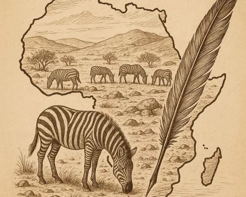
NASA and the University of Cape Town (UCT) have joined forces for a four-year initiative called BioSCape, aimed at mapping the biodiversity of South Africa’s Greater Cape Floristic Region. The project will use satellite and aerial data in combination with on-the-ground observations to map marine, freshwater, and terrestrial species and ecosystems within the region. It is hoped this will strengthen conservation efforts and biodiversity research, whilst offering pioneering resources for charting and monitoring the diverse living organisms in one of the world’s most biodiverse areas. The BioSCape project is a testament to world-class biodiversity research in South Africa and represents an ambitious leap forward in the understanding and conservation of unique ecosystems.
What is the BioSCape initiative?
The BioSCape initiative is a four-year partnership between NASA and the University of Cape Town (UCT) to deepen the understanding of the Greater Cape Floristic Region’s biodiversity. This collaboration integrates satellite and aerial data with on-the-ground observations to map marine, freshwater, and terrestrial species and ecosystems within the region. The project aims to strengthen conservation efforts and biodiversity research within the region.
A Unique Collaboration for Biodiversity Research
In a groundbreaking collaboration, the US National Aeronautics and Space Administration (NASA) and the University of Cape Town (UCT) have partnered to explore the rich biodiversity of the Western Cape, South Africa. The ambitious project, named BioSCape, will last for four years (until 2024) and aims to deepen the understanding of the Greater Cape Floristic Region (GCFR) as well as its surrounding coastal and marine ecosystems. The primary focus is to strengthen conservation efforts and biodiversity research within the region.
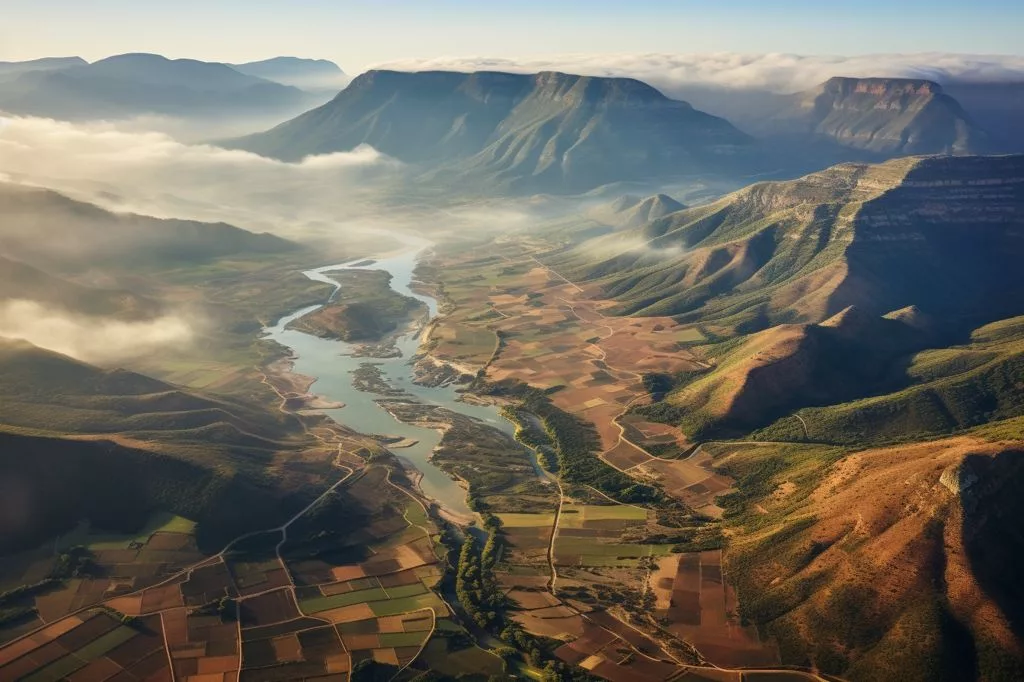
The BioSCape initiative will offer a comprehensive view of the region’s diverse terrain by integrating satellite and aerial data with on-the-ground observations. This combination of perspectives will enable a global community of scientists to gain a deeper understanding of the area’s rich biodiversity. The collaborative effort will involve experts from the United States and South Africa working together to map marine, freshwater, and terrestrial species and ecosystems within the region.
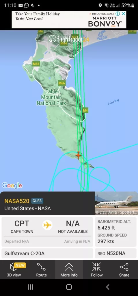
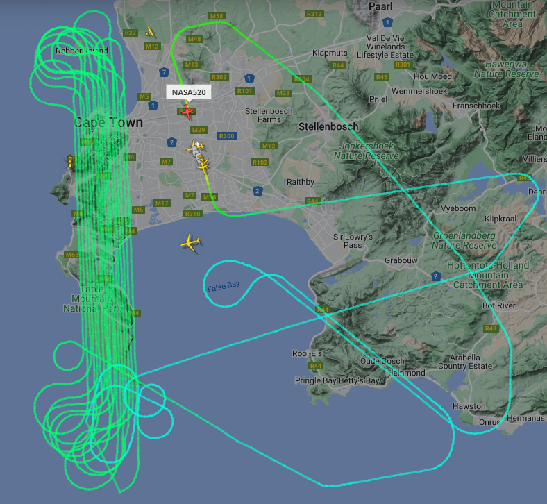

As part of the project, NASA will dispatch two modified jets – a Gulfstream III and potentially a Gulfstream V – to Cape Town to gather ultraviolet, visual, and thermal imagery data over a period of four to six weeks. The aircraft will also utilize LiDAR technology to measure vegetation height and structure. In addition to aerial support, the project will depend on satellites and ground teams to observe and document plant and animal life, enabling the mapping of biodiversity, species distribution, ecosystem boundaries, and a deeper understanding of ecosystem structure and composition.
Unprecedented Insights into Biodiversity and Conservation
Dr. Jasper Slingsby, a renowned South African scientist and faculty member at UCT, has emphasized the potential of the BioSCape project to illuminate the region’s biodiversity. He believes that the initiative will offer pioneering resources for charting and monitoring the diverse living organisms found in one of the world’s most biodiverse areas. Moreover, the data acquired through BioSCape will be crucial in devising effective strategies for conserving and managing the GCFR’s numerous ecosystems. Dr. Slingsby also highlights the project’s potential to enhance our understanding of the impacts of climate change on biodiversity.
The BioSCape flights are planned between late October and November to coincide with the flowering of fynbos plants and to accommodate the region’s weather conditions. The project reflects the collaborative spirit of numerous South African research and conservation partners, including the National Research Foundation (NRF), the South African Environmental Observation Network (SAEON), the South African National Biodiversity Institute (SANBI), the South African National Space Agency (SANSA), South African National Parks (SANParks), and CapeNature.
A Testament to World-Class Biodiversity Research in South Africa
Dr. Mary-Jane Bopape, Managing Director of SAEON, expressed her excitement for the groundbreaking project, stating that it is indicative of the world-class biodiversity research being conducted in South Africa. She affirmed SAEON’s commitment to contributing to data collection and utilizing the information generated by BioSCape to inform environmental management decisions in the region.
The BioSCape project represents an ambitious leap forward in the understanding and conservation of the unique ecosystems that thrive within the Greater Cape Floristic Region. By harnessing the power of cutting-edge technology, international collaboration, and the passion and expertise of scientists across multiple disciplines, the initiative has the potential to set a new standard for biodiversity research and conservation efforts worldwide.
What is the Greater Cape Floristic Region (GCFR)?
The Greater Cape Floristic Region (GCFR) is a biodiversity hotspot located in the Western Cape of South Africa. It is home to a unique and diverse range of plant and animal species, many of which are found nowhere else in the world.
How will the BioSCape project map biodiversity in the GCFR?
The BioSCape project will use satellite and aerial data in combination with on-the-ground observations to map marine, freshwater, and terrestrial species and ecosystems within the Greater Cape Floristic Region. The project aims to offer a comprehensive view of the region’s diverse terrain, enabling a global community of scientists to gain a deeper understanding of the area’s rich biodiversity.
What aircraft will be used for the BioSCape flights?
NASA will dispatch two modified jets – a Gulfstream III and potentially a Gulfstream V – to Cape Town to gather ultraviolet, visual, and thermal imagery data over a period of four to six weeks. The aircraft will also utilize LiDAR technology to measure vegetation height and structure.
When will the BioSCape flights take place?
The BioSCape flights are planned between late October and November to coincide with the flowering of fynbos plants and to accommodate the region’s weather conditions.
What organizations are partnering with NASA and UCT for the BioSCape project?
Numerous South African research and conservation partners are collaborating on the BioSCape project, including the National Research Foundation (NRF), the South African Environmental Observation Network (SAEON), the South African National Biodiversity Institute (SANBI), the South African National Space Agency (SANSA), South African National Parks (SANParks), and CapeNature.
What will the data acquired through BioSCape be used for?
The data acquired through BioSCape will be crucial in devising effective strategies for conserving and managing the GCFR’s numerous ecosystems. It will also enhance our understanding of the impacts of climate change on biodiversity.
How long will the BioSCape project last?
The BioSCape project is a four-year initiative that will last until 2024.
What is the significance of the BioSCape project for biodiversity research and conservation efforts?
The BioSCape project represents an ambitious leap forward in the understanding and conservation of the unique ecosystems that thrive within the Greater Cape Floristic Region. By harnessing the power of cutting-edge technology, international collaboration, and the passion and expertise of scientists across multiple disciplines, the initiative has the potential to set a new standard for biodiversity research and conservation efforts worldwide.