Cape Town has created a clear boundary called the Urban Development Edge to guide where the city can grow without harming nature. This smart plan helps the city grow while protecting important lands like wetlands and farms. It also makes building new homes and roads faster and easier, as long as sensitive areas stay safe. By working together with many people, Cape Town is leading the way in balancing urban growth with caring for the environment. This new approach invites everyone to help shape a city that grows smartly and stays beautiful.
What is Cape Town’s Urban Development Edge and how does it impact urban growth and conservation?
Cape Town’s Urban Development Edge (UDE), adopted in 2025 under the National Environmental Management Act, sets clear boundaries for city expansion. It balances urban growth with environmental protection by guiding development, streamlining approvals, and safeguarding sensitive ecosystems. This framework promotes sustainable, efficient, and inclusive urban planning.
Charting a New Course: The Urban Development Edge
Cape Town’s relationship with its landscape has always been vivid, marked by both the allure of its natural beauty and the pressures of a growing city. On July 16, 2025, the city reached a historic milestone when the Western Cape Department of Environmental Affairs and Development Planning officially adopted Environmental Management Frameworks (EMFs) under the National Environmental Management Act (NEMA). This move established, for the first time in South Africa, a legally recognized Urban Development Edge (UDE) with national oversight—a clear boundary that will shape where the city grows and how it balances expansion with environmental protection.
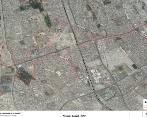
The UDE is more than a boundary on a map; it is a conceptual and practical tool for guiding growth. First approved by the City Council in January 2023, this line outlines the outermost limits for new development, incorporating agricultural fields and undeveloped tracts at the city’s margins. By defining these borders, city planners aim to accommodate inevitable population increases while safeguarding vital ecosystems and upholding the city’s unique character.
This strategy reflects Cape Town’s ongoing challenge: how to expand and modernize without erasing the features that make the city extraordinary. The UDE represents a careful compromise—an attempt to maintain both the vibrancy of human settlement and the integrity of the natural environment. It signals Cape Town’s commitment to responsible urban planning, blending the needs of its residents with a respect for the land that sustains them.
Building the Framework: Collaboration and Innovation
The implementation of Environmental Management Frameworks in Cape Town did not happen overnight. Over two years, the city engaged a wide spectrum of stakeholders in a collaborative process. National departments, local authorities, environmental consultants, community groups, and technical experts all contributed to shaping the guidelines that would govern future development. This inclusive approach ensured that the frameworks would be both robust and practical, reflecting local realities while meeting national standards.
These EMFs serve as comprehensive guides for decision-making. They map out sensitive natural features—rivers, wetlands, critical biodiversity corridors—and overlay them with the city’s spatial development plans. This alignment helps planners prioritize areas for protection while identifying sites more suitable for housing, industry, and infrastructure. In effect, EMFs provide a blueprint for integrating ecological priorities into the everyday business of city-building.
The significance of Cape Town’s EMF adoption extends beyond its borders. By merging the UDE with NEMA requirements, Cape Town has created a precedent for other South African cities. The result is a new model for urban environmental governance—one that seeks efficiency without abandoning ecological responsibility, and that encourages transparent, data-driven decision-making.
Streamlining Development: Reducing Delays, Raising Standards
One of the most immediate benefits of Cape Town’s new frameworks lies in regulatory reform. Previously, nearly all new projects—regardless of location or environmental impact—had to undergo lengthy and expensive Environmental Impact Assessments (EIAs) as mandated by NEMA. This process often stymied development, frustrated landowners, and created confusion among professionals eager to deliver much-needed infrastructure.
With the gazetting of the EMFs and UDE, most activities within the designated Urban Area are now exempt from the usual EIA requirements, provided they do not affect sensitive environments. Developers and city planners can consult clear, up-to-date maps to see whether their proposed sites trigger any environmental red flags. If not, they can proceed with greater certainty, knowing that the regulatory path is unobstructed by unnecessary hurdles.
However, the city has not sacrificed sustainability for expediency. Rivers, floodplains, wetlands, and high-value natural habitats remain strictly protected. These areas continue to fall under NEMA, the National Water Act, and municipal bylaws. This targeted approach means city officials can focus their oversight and resources on protecting the most vulnerable places, while streamlining approvals for lower-impact developments in already disturbed or agricultural zones.
For those working in Cape Town’s property and infrastructure sectors, these changes promise major savings in time and cost. Instead of navigating a maze of redundant permissions, professionals can rely on clear guidelines and predictable processes. This efficiency not only accelerates the delivery of services and housing but also attracts investment to areas designed for sustainable expansion.
Looking to the Future: Adaptability and Shared Stewardship
Cape Town’s Urban Development Edge is deliberately flexible. The city has resolved to revisit and revise the UDE every five years, in tandem with updates to its Municipal Spatial Development Framework and related plans. This regular review ensures that the boundaries remain responsive to new environmental data, shifting community needs, and evolving growth patterns.
Urban planners describe this cycle as a chance to “redraw the city’s portrait”—an opportunity to correct past missteps, incorporate lessons learned, and integrate the latest scientific insights. The process invites ongoing public participation and scrutiny, reinforcing a culture of collective stewardship over Cape Town’s future.
Cape Town’s experiment stands in the broader tradition of cities that have tried to reconcile progress with preservation. From London’s green belts to Portland’s urban growth boundaries, planners around the world have grappled with how to contain sprawl while nurturing vibrant, livable communities. Yet, Cape Town’s context is distinct. With the floristic riches of the Cape Fold Belt and a city identity forged through centuries of cultural convergence, the stakes—and the opportunities—are uniquely high.
The city’s new frameworks do not dictate a one-size-fits-all solution. Instead, they offer a dynamic system for managing growth, protecting resources, and fostering civic engagement. By opening up access to detailed maps and guidance online, Cape Town empowers citizens to monitor and shape the forces transforming their neighborhoods.
Cape Town’s adoption of the EMFs and Urban Development Edge marks a turning point in South Africa’s approach to environmental governance. The city has shown that it is possible to accelerate necessary development without undermining crucial ecosystems. By balancing clarity, efficiency, and vigilance, Cape Town has set a standard for thoughtful, inclusive urban planning.
This achievement relies on more than legal frameworks and technical expertise. It depends on the willingness of city leaders, professionals, and residents alike to remain engaged, informed, and adaptable. The tools now in place invite everyone to become part of the ongoing project of shaping a Cape Town that remains both dynamic and deeply rooted in its landscape—a city where aspirations for growth and commitments to conservation can coexist and thrive.
What is Cape Town’s Urban Development Edge (UDE)?
Cape Town’s Urban Development Edge (UDE) is a legally recognized boundary established in 2025 under the National Environmental Management Act (NEMA) to guide the city’s expansion. It sets clear limits for urban growth to balance development needs with the protection of sensitive ecosystems like wetlands, rivers, and biodiversity corridors. The UDE helps planners direct new housing, infrastructure, and industry to suitable areas while safeguarding important natural and agricultural lands at the city’s margins.
How does the Urban Development Edge improve the development approval process?
Before the UDE and Environmental Management Frameworks (EMFs), nearly all new developments required lengthy Environmental Impact Assessments (EIAs), which delayed projects and increased costs. Now, most activities within the Urban Development Edge that do not affect sensitive environments are exempt from EIAs. Developers can consult detailed maps showing protected areas and proceed more quickly if their sites fall outside these zones. This streamlines approvals, reduces uncertainty, and encourages investment in sustainable urban growth.
What role do Environmental Management Frameworks (EMFs) play alongside the UDE?
EMFs complement the UDE by providing comprehensive, data-driven guidance for decision-making. They overlay Cape Town’s spatial plans with maps of critical natural features, helping to identify where development can occur without harming the environment. Developed collaboratively with government agencies, experts, and community groups, EMFs ensure that growth respects ecological priorities while meeting national environmental standards. They serve as practical tools to integrate conservation into everyday urban planning.
How does Cape Town ensure the UDE remains relevant over time?
The city commits to reviewing and updating the Urban Development Edge every five years, alongside the Municipal Spatial Development Framework and related plans. This iterative process allows Cape Town to adapt boundaries based on new environmental data, shifting population needs, and lessons learned from previous cycles. Public participation is encouraged during these reviews, fostering transparency and shared stewardship of the city’s growth and natural heritage.
What environmental areas are protected under the UDE and related regulations?
Despite streamlining development in many areas, Cape Town maintains strict protections for sensitive environments such as rivers, floodplains, wetlands, and high-value habitats. These zones remain regulated under NEMA, the National Water Act, and municipal bylaws. The focused oversight ensures the most vulnerable ecosystems are preserved, maintaining biodiversity and natural services, while allowing development to proceed responsibly elsewhere.
Why is Cape Town’s approach to urban growth and conservation considered a breakthrough?
Cape Town’s integration of the Urban Development Edge with Environmental Management Frameworks represents a pioneering model for South African cities. It balances efficient, inclusive urban growth with robust environmental protection, something many rapidly growing cities struggle to achieve. By reducing regulatory delays without compromising sustainability, encouraging collaborative governance, and committing to ongoing adaptation, Cape Town sets a new standard for smart, environmentally conscious urban planning.