South Africa is bracing for heavy rainfall which is expected to cause chaos in various provinces, including potential floods and river overflows. The South African Weather Service (SAWS) has issued a warning and urged the public to stay informed about forecasts and pay heed to warnings issued by SAWS. Disaster management professionals are also recommended to sustain a heightened level of alertness during this time to manage possible safety and health threats.
Warning of Looming Weather Turmoil
The South African Weather Service (SAWS) has issued a warning about heavy rainfalls that could cause chaos in various provinces, resulting in potential floods or river overflows. Disaster management professionals are recommended to sustain a heightened level of alertness during this time to manage safety and health threats. The public is urged to stay informed with weather forecasts and pay heed to warnings issued by SAWS.
Warning of Looming Weather Turmoil
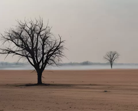
The South African Weather Service (SAWS) has issued a stern warning, alerting about substantial heavy rainfalls that could cause chaos in various provinces in the ensuing days. This meteorological turmoil is anticipated to result in considerable disruptions such as potential floods or river overflows. Nonetheless, the preliminary days of the weekend are expected to be tranquil, with a minimal likelihood of thunderstorms in a few of the eastern provinces on Friday and Saturday.
Remarkably, the Western Cape and the Eastern Cape are not at risk of being directly affected by this meteorological turmoil. Yet, on Sunday, December 10, the weather conditions are projected to deteriorate. The cut-off low, a weather anomaly, will dominate the northern areas of the Northern Cape, infusing notable instability into the atmosphere and initiating widespread showers and thundershowers.
Incoming Weather Developements
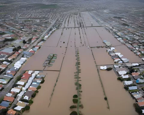
As tropical air from Botswana begins to flow southward over South Africa, conditions will progressively become cloudy to overcast. Rainfall will commence enveloping various provinces including North West, the Free State, Gauteng, Mpumalanga, Limpopo, and to a lesser degree, KwaZulu-Natal (KZN). SAWS has cautioned that this intense precipitation could escalate the risk of both localized and river flooding.
In anticipation of these upcoming weather conditions, the public has been urged to keep abreast with regular weather forecasts and pay heed to warnings issued by SAWS. Furthermore, the persistent rainfall could result in the ground reaching saturation point, triggering widespread overland drainage into rivers and streams. Although this could cause an increase in dam levels, it could also result in traffic disruptions and road closures due to river flooding.
Disaster management professionals are recommended to sustain a heightened level of alertness during this time to manage possible safety and health threats. As a safety measure, drivers and pedestrians are strongly advised to refrain from attempting to traverse rivers or streams that have already been flooded.
The Underlying Causes and the Aftermath
The imminent rainy weather stems from three unique atmospheric circulation features over southern Africa. Firstly, a cut-off low is projected to form in the upper air of the atmosphere over the central interior during the later part of the weekend. Secondly, a surface trough is anticipated to intensify in correlation with the deepening upper-air cut-off low. The coalescing of these two features is renowned for triggering widespread, often heavy, rain over southern Africa.
The influx of a flow of tropically sourced moisture, pulled southwards over the central and eastern interior of South Africa, is the third significant factor anticipated to elevate the risk of heavy rainfall. Tropically sourced air is infamous for its correlation with potentially heavy, widespread rainfall.
Forecast models propose that the rainfall will start to clear from the west on Tuesday, December 12. However, areas of heavier rainfall may still persist over KZN, Eswatini, and the Lowveld regions of Mpumalanga and Limpopo. A surface high-pressure system could maintain light rainfall over the aforementioned provinces on Wednesday, December 13, as cooler, moist maritime air is introduced to the eastern coastal regions.
Staying Aware and Prepared
SAWS will be closely monitoring this weather system and will persist in issuing updates and impact-based warnings in the following days. The agency implores the public to stay informed with weather forecasts through television, radio, and social media. Updated information will also be accessible on their website and other platforms for the convenience of the public.
What is the warning issued by SAWS?
SAWS has issued a warning about heavy rainfalls that could cause chaos in various provinces, resulting in potential floods or river overflows.
Which provinces are expected to be affected by heavy rainfall?
North West, the Free State, Gauteng, Mpumalanga, and Limpopo are expected to be affected by heavy rainfall, while KwaZulu-Natal is expected to be affected to a lesser degree.
What should the public do to stay informed about the weather forecasts?
The public is urged to stay informed with weather forecasts and pay heed to warnings issued by SAWS through television, radio, and social media. Updated information will also be accessible on their website and other platforms for the convenience of the public.
What are the potential safety and health threats that disaster management professionals need to manage during this time?
Disaster management professionals need to sustain a heightened level of alertness during this time to manage possible safety and health threats, such as traffic disruptions and road closures due to river flooding.
What are the causes of the imminent rainy weather?
The imminent rainy weather stems from three unique atmospheric circulation features over southern Africa: a cut-off low in the upper air of the atmosphere, a surface trough intensifying in correlation with the deepening upper-air cut-off low, and a flow of tropically sourced moisture pulled southwards over the central and eastern interior of South Africa.
When is the rainfall expected to clear, and which areas may still experience heavier rainfall?
Forecast models propose that the rainfall will start to clear from the west on Tuesday, December 12. However, areas of heavier rainfall may still persist over KZN, Eswatini, and the Lowveld regions of Mpumalanga and Limpopo.