A powerful storm is brewing near the Western Cape, bringing dangerous weather like heavy rain, thunderstorms, hail, and strong winds. This cut-off low pressure system is expected to start affecting the region soon, causing possible flooding and travel troubles for everyone. Residents are urged to stay alert and prepare for the storm’s impact, as it could also affect nearby areas. While this wild weather poses serious challenges, it’s a reminder of nature’s strength and the importance of community support during tough times.
What impacts can the cut-off low pressure system bring to the Western Cape?
The cut-off low pressure system approaching the Western Cape is expected to bring severe weather, including:
– Thunderstorms
– Torrential rain
– Hail
– Intense lightning
– Destructive winds
Residents should prepare for potential flooding, travel disruptions, and property damage.
A Brewing Meteorological Storm
Nature’s unending cycles often bring forth events that seize our attention, and this week is no different. Off the west coast of South Africa, a formidable weather system is forming, promising to deliver a dramatic display of meteorological intensity. The Western Cape, renowned for its breathtaking landscapes, is now facing a significant challenge as a cut-off low pressure system (COL) churns ominously about 1,000 kilometers northwest of Cape Town.
Cut-off lows detach from the main jet stream, drifting slowly and unpredictably. These atmospheric phenomena are notorious for causing severe weather, and this particular COL is no exception. As it moves southeastward over the Atlantic Ocean, it is expected to bring thunderstorms, torrential rain, hail, intense lightning, and destructive winds to the region.
The early signs of this powerful system began appearing on Monday. Satellite images and wind maps captured the initial development of thunderstorms to the west of South Africa. The swirling motion of the COL indicates its growing strength and slow but steady approach toward the mainland. By Monday evening, meteorologists predict that the Western Cape, including its interior and possibly the Cape Metropole, will start feeling the effects of the storm.
Escalating Alerts and Warnings
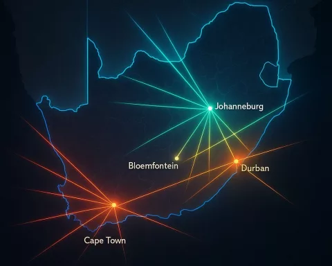
The South African Weather Service (SAWS) has heightened its alert status, anticipating the need for multiple warnings throughout the week. Monday’s forecast outlines an extensive impact zone that extends beyond South Africa’s borders, affecting southeastern Namibia, southwestern Botswana, and parts of the Northern Cape, North West, Free State, and northwestern KwaZulu-Natal. This wide array of affected areas highlights the far-reaching implications of the impending storm.
As Tuesday arrives, the storm’s intensity is expected to increase, spreading its disruptive influence further into the Eastern Cape, Lesotho, and deeper into the Western Cape, placing Cape Town directly in its path. The peak of concern is expected on Wednesday morning, when the storm’s trailing edge could bring heavy rain to the southeastern regions of the Western Cape and southwestern parts of the Eastern Cape. This level of precipitation could lead to localized flooding, travel disruptions, and significant property damage, creating a grim scenario for residents and local authorities.
By midweek, the storm is projected to move inland, potentially affecting Gauteng, western Mpumalanga, parts of Limpopo, and eastern KwaZulu-Natal with severe weather conditions. The interaction of atmospheric elements over these regions could result in complex and volatile weather patterns as the system progresses.
Preparing for the Onslaught
Residents across the affected areas are urged to stay vigilant and monitor updates from the SAWS, which is prepared to issue crucial warnings and advisories. Experts emphasize the importance of caution, particularly in avoiding flood-prone areas and adhering to storm safety protocols. The threat of hail and high winds further elevates the risk, underscoring the need for thorough preparedness.
The unfolding story of this storm system serves as a powerful reminder of nature’s unpredictability and raw power. It also highlights the critical role of meteorological science and the dedicated professionals who interpret and communicate atmospheric data. Historical storms, from the fierce squalls of the Baroque era to the devastating hurricanes of recent times, illustrate the enduring relationship between humanity and the elements.
In an age of advanced technology and sophisticated forecasting models, our capacity to predict and prepare for such events has greatly improved. However, the inherent unpredictability of cut-off low systems reminds us of the limits of our understanding. The Western Cape’s upcoming encounter with this COL underscores the urgent need for readiness and evokes the timeless human experience of confronting nature’s grandeur.
Reflecting on Resilience and Interconnectedness
As we observe the storm’s progression, we are reminded of the interconnectedness of regions and communities in facing shared environmental challenges. The Western Cape, with its rich cultural heritage and historical significance, stands resilient, supported by the spirit and determination of its people. While this impending weather event poses significant dangers, it also offers an opportunity to reinforce the communal bonds within the region.
In conclusion, the approaching cut-off low pressure system off South Africa’s west coast represents a formidable natural phenomenon and a considerable challenge. The anticipated impacts, spanning multiple provinces and neighboring countries, call for heightened awareness and preparedness. As the storm unfolds, the collective resilience of the affected communities will be tested, highlighting the enduring interplay between humanity and the untamed forces of nature.
FAQ: The Looming Storm in the Western Cape
What is a cut-off low pressure system, and how does it affect weather?
A cut-off low pressure system is a weather phenomenon that detaches from the main jet stream, drifting slowly and unpredictably. It typically causes severe weather events, such as thunderstorms, torrential rain, hail, and strong winds. The current cut-off low pressure system near the Western Cape is expected to bring these dangerous conditions to the region.
What specific weather impacts are expected from the approaching storm?
Residents in the Western Cape can expect a range of severe weather impacts, including:
– Thunderstorms
– Heavy rain
– Hail
– Intense lightning
– Destructive winds
These conditions may lead to flooding, travel disruptions, and property damage, prompting residents to prepare accordingly.
When is the storm expected to reach the Western Cape?
The storm system is anticipated to begin affecting the Western Cape soon, with early signs of its impact already developing. By Tuesday, the storm’s intensity is expected to increase, and the peak of concern is forecasted for Wednesday morning, when heavy rain is expected in the southeastern regions of the Western Cape and southwestern parts of the Eastern Cape.
How wide is the impact zone of the storm?
The South African Weather Service (SAWS) has projected that the storm will have a significant impact beyond the Western Cape. Areas affected include southeastern Namibia, southwestern Botswana, and various parts of South Africa, including the Northern Cape, North West, Free State, and northwestern KwaZulu-Natal, highlighting the storm’s extensive reach.
What precautions should residents take in preparation for the storm?
Residents are advised to stay vigilant and monitor updates from the SAWS. It is crucial to avoid flood-prone areas and follow storm safety protocols. Preparing emergency kits, securing property, and having a communication plan in place are vital steps to ensure safety during the storm.
How can communities support each other during this storm?
The impending storm emphasizes the importance of community support and resilience. Neighbors can check on one another, share resources, and stay informed together. This collective spirit strengthens bonds and enhances safety, illustrating the interconnectedness of communities in facing environmental challenges.